යාපනය නගරය
ශ්රී ලංකාවේ උතුරු කෙළවරේ පිහිටි යාපනය අර්ධද්වීපයේ ප්රධාන නගරය යාපනයයි. කොළඹ සිට සුවපහසු නගරාන්තර බස් රථ මගින් යාපනය නගරයට ළඟා වීමට පැය 10-12 ක් ගතවේ.
Mullaitivu City
Mullaitivu is the main town of Mullaitivu District, situated on the north-eastern coast of Northern Province, Sri Lanka. A largely fishing settlement, the town in the early twentieth century grew as an anchoring harbour of the small sailing vessels transporting goods between Colombo and Jaffna. The town has a District Secretary's office, many other government institutions and schools located in and around the area.
During the Kandyan Wars, the British government house in Mullaitivu was attacked by forces of Pandara Vanniyan and Dissava of Nuwara Kalawiya and lay siege to the fort. Captain Drieberg with his force of Malays escaped from the fort in boats and reached Jaffna. During the Sri Lankan Civil War, Mullaitivu became an isolated base for the Sri Lankan armed forces. In a pitched battle the LTTE succeeded in over running the base in 1996. Following this the Sri Lankan armed forces withdrew from Mullaitivu which allowed the LTTE to gain control of the area. It was damaged by the 2004 Indian Ocean tsunami with a large loss of life. The Sri Lankan Army took control of the town on January 25, 2009, in the Battle of Mullaitivu in its offensive against the LTTE. Security Forces Headquarters – Mullaitivu was established on June 5, 2009 in the town.
About Mullaitive District
Mullaitivu District is one of the 25 districts of Sri Lanka, the second level administrative division of the country. The district is administered by a District Secretariat headed by a District Secretary (previously known as a Government Agent) appointed by the central government of Sri Lanka. The capital of the district is the town of Mullaitivu.
Parts of present-day Mullaitivu District was part of the pre-colonial Jaffna kingdom. The district then came under Portuguese, Dutch and British control. In 1815 the British gained control of the entire island of Ceylon. They divided the island into three ethnic based administrative structures: Low Country Sinhalese, Kandyan Sinhalese and Tamil. The district, which was then part of Vanni District, was part of the Tamil administration. In 1833, in accordance with the recommendations of the Colebrooke-Cameron Commission, the ethnic based administrative structures were unified into a single administration divided into five geographic provinces. Vanni District, together with Jaffna District and Mannar District, formed the new Northern Province.
යාපනය දිස්ත්රික්කය ගැන
යාපනය ශ්රී ලංකාවේ උතුරු පළාතේ අගනුවරයි. යාපනය සහ කිලිනොච්චි දිස්ත්රික්කවල ජනගහනයෙන් 85% ක් හින්දු භක්තිකයන් වේ. හින්දු භක්තිකයන් සයිවයිට් සම්ප්රදාය අනුගමනය කරති. ඉතිරි අය බොහෝ දුරට රෝමානු කතෝලිකයන් හෝ රෙපරමාදු භක්තිකයන් වන අතර, ඔවුන්ගෙන් සමහරක් බර්ගර්වරුන් ලෙස හැඳින්වෙන යටත් විජිත පදිංචිකරුවන්ගෙන් පැවත එන්නන් වේ. දෙමළ ජනයා කුල රේඛා ඔස්සේ බෙදී ඇති අතර, ගොවි-කුල වෙල්ලාලර් බහුතරය වේ. මුහුදු නිෂ්පාදන, රතු ළූණු සහ දුම්කොළ යාපනයේ ප්රධාන නිෂ්පාදන වේ.
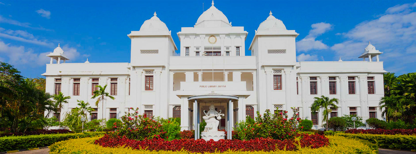
යාපනය සුන්දර හින්දු කෝවිල් වලට නිවහන වේ. පැරණි ලන්දේසි බලකොටුවක් තවමත් හොඳින් සංරක්ෂණය කර ඇති අතර එහි පැරණි පල්ලියක් ඇත. ලන්දේසි ගෘහ නිර්මාණ ශිල්පයේ තවත් උදාහරණයක් වන්නේ රජ මන්දිරයයි. යාපනයට යන ඕනෑම සංචාරයක් එහි පැණි රස සඳහා ප්රසිද්ධ වූ අතිවිශිෂ්ට යාපනය අඹ රස නොබලා සම්පූර්ණ නොවේ. කිලෝමීටර 3 ක් පමණ දුරින් යාපනයේ විශාලතම ආගමික උත්සවය පැවැත්වෙන තේජාන්විත නල්ලූර් කන්දස්වාමි කෝවිල පිහිටා ඇත. කයිට්ස් වරාය යනු යාපනය කලාපයේ පුරාණ නැව් තටාක ස්ථානයකි.
උතුරු පළාත ගැන
උතුරු පළාත ශ්රී ලංකාවේ පළාත් 9 න් එකකි. මෙම පළාත් 19 වන සියවසේ සිට පැවතුනද, 1978 ශ්රී ලංකා ආණ්ඩුක්රම ව්යවස්ථාවට 13 වන සංශෝධනය මගින් පළාත් සභා පිහිටුවන තෙක් ඒවාට කිසිදු නීතිමය තත්වයක් නොතිබුණි. 1988 සහ 2006 අතර කාලය තුළ පළාත තාවකාලිකව නැගෙනහිර පළාත සමඟ ඒකාබද්ධ කර ඊසානදිග පළාත පිහිටුවන ලදී. පළාතේ අගනුවර යාපනයයි.
උතුරු පළාත ශ්රී ලංකාවේ උතුරේ පිහිටා ඇති අතර ඉන්දියාවෙන් සැතපුම් 22 (කිලෝමීටර් 35) ක් දුරින් පිහිටා ඇත. මෙම පළාත බටහිරින් මන්නාරම් බොක්ක සහ පෝක් බොක්ක, උතුරින් පෝක් සමුද්ර සන්ධිය, නැගෙනහිරින් බෙංගාල බොක්ක සහ දකුණින් නැගෙනහිර, උතුරු මැද සහ වයඹ පළාත්වලින් වට වී ඇත. පළාතේ කලපු ගණනාවක් ඇති අතර, විශාලතම ඒවා වන්නේ යාපනය කලපුව, නන්ති කඩල්, චුන්ඩික්කුලම් කලපුව, වඩමාරච්චි කලපුව, උප්පු ආරු කලපුව, කොක්කිලායි කලපුව, නයි ආරු කලපුව සහ චලයි කලපුවයි. ශ්රී ලංකාව වටා ඇති දූපත් බොහොමයක් උතුරු පළාතේ බටහිර දෙසින් සොයාගත හැකිය. විශාලතම දූපත් වන්නේ: කයිට්ස්, නෙඩුන්තිව්, කරයිතිව්, පුන්ගුඩුතිව් සහ මණ්ඩතිව්.
2007 දී උතුරු පළාතේ ජනගහනය 1,311,776 ක් විය. ජනගහනයෙන් බහුතරය ශ්රී ලාංකික දෙමළ ජාතිකයන් වන අතර, සුළුතරයක් ශ්රී ලාංකික මුවර් සහ සිංහල ජනගහනයයි. පළාතේ ජනගහනයෙන් අතිමහත් බහුතරයක් කතා කරන ප්රධාන භාෂාව ශ්රී ලාංකික දෙමළ වේ. අනෙක් භාෂාව ජනගහනයෙන් සියයට 1 ක් කතා කරන සිංහල වේ. නගරවල ඉංග්රීසි බහුලව කතා කරන අතර තේරුම් ගනී.